|
(please click to enlarge)
|
INTRODUCTION TO DAK LAK PROVINCE
Located in the Southern part of Vietnam’s central region, Dak Lak Province covers 1,312,537 ha with a population of 1,737 Million. Dak Lak is divided into 14 administrative districts. The province has a good transport network including highway 14, 26 and 27 and the Buon Ma Thuot Airport, which connect Dak Lak with other provinces in the Central Highlands, in the coastal areas and with Ho Chi Minh City and Hanoi.
Dak Lak’s climate is characterised by a distinctive rainy season from April to November and a dry season from December to April. The province’s altitude ranges between 500 to 800 meters above see level. As such, its climate is affected by both, tropical monsoon and highland conditions resulting in an agricultural potential that is suitable for a wide range of perennial crops, including coffee, pepper, rubber, cashew and cotton.
Land constitutes the strength and potential of Dak Lak. The province boasts over 360.000 ha of basaltic soils, suitable for seasonal and perennial cash crops, especially coffee and rubber. The remaining land consists predominantly of alluvial soils for cultivation of rice and beans. It also has large areas of forests with potential timber reserves, diverse biological resources and abundant flora and fauna. Many of its rare and precious animals have been listed in the world red list. Dak Lak is abundant of such minerals as kaolin, gold, lead, peat, and precious gems.
The potential for tourism in Dak Lak is great, considering its magnificent landscapes and diverse cultures of various ethnic minorities. Major tourist attractions include Dray Sap Waterfall, Buon Don “The elephant village”, Lak Lake and other eco-tourist spots.
44 ethnic minorities coexist in Dak Lak. Apart from the indigenous groups such as the Ede, M'Nong or Jarai, there are several ethnic groups which originate form other provinces in the Northern regions of the country including the Tay, Nung, Muong, Dao, Thai and H'Mong.
Since reunification of Vietnam in 1975, Dak Lak’s socio economic development has progressed rapidly. In 2005, annual GDP growth reached 11.5-12%. In 2005, average per capita income was USD 497. This was an impressive economic growth, considering the province’s population growth from 1,026 million in 1990 to 1,734 million in 2006.
Agriculture and forestry production has developed at an average growth rate of 15.2% during the 2001-2005 period. Land under cultivation has increased 1.6 times to 466,426 ha in 2006. Special areas have been set aside for industrial and cash crops, of which 170,403 ha are under coffee, resulting in an output of 400,000 tons. Rubber accounts for 22,809 ha and 20,118 tons. The province has 3,567 ha of pepper and cotton production increased to 3,718 ha.
Tabel 1: Facts about Dak Lak Province (status 2006):
|
Land Area |
1,312,537 ha |
|
Agriculture land |
478,154 ha |
|
Forest land |
602,479 ha |
|
Population |
1,737,376 |
|
Ethnic Minority Groups |
|
|
Ede |
287,844 (16.6%) |
|
Mnong |
38,668; (2.2%) |
|
J’Rai |
13,872; (0.8%) |
|
other indigenous groups incl. |
|
|
immigrated minority groups |
214,496 (12.4%) |
|
Administrative structure |
|
|
Districts |
14 |
|
Commune / communal units / towns |
185 |
|
Villages |
2285 |
Dak Lak’s industry and construction sector have made encouraging progresses, thus improving the industrial production capacity and diversification of products. The province’s industry has been continuously built up, including such sectors as electricity, construction materials, mechanical engineering, and processing. Many modern medium scaled industrial establishments have been put into operation, e.g. processing of coffee, sugar cane, timber and cotton. From 2000 to 2005, Dak Lak’s industrial output value increased by 12.4% annually, generating jobs for thousands of labourers. The impressive development of the electricity sector as well as the post and telecommunication infrastructure creates favourable conditions for the development of the business and service sectors in the rural areas. All districts and communes in Dak Lak Province are connected to the national grid; 155 out of 185 communes are connected to the telephone network.
With regard to export, the province has extended its markets and developed into an export-oriented market economy. In 2006, Dak Lak’s export turnover reached USD 380 million. The service sector has seen positive changes, striving to be suitable for the market economy.
Apart from the economic achievements, social sectors in Dak Lak have also progressed considerably. School facilities have been improved and upgraded. Dak Lak has been acknowledged for the achievement of the national standard on primary education and the eradication of illiteracy in 5 from 14 districts. During the school year 2006/07, 524,796 students attended primary and secondary schools. The network of health care units has been expanded to commune level and staffed with doctors. The efforts towards hunger eradication and poverty reduction have helped to reduce the proportion of poor households in the province to 23% (2006).
Table 2: Major Socio-Economic Indicators (status 2006 in VND current prices)
|
GDP (total / annual growth in %) |
10,411.5 Bill. (11.5-12%) |
|
|
Agriculture/forestry/fishery |
5,612.2 Bill. (53.9%) |
|
|
Industry / construction |
1,949.2 Bill. (18.7%) |
|
|
Services |
2,850.1 Bill. (27.4%) |
|
|
Export volume |
388.4 Mio. US$ |
|
|
Avg. per capita income |
497 US$ |
|
|
Poor households |
90,247 HHs (23%) |
|
|
Output in Agriculture: |
|
|
|
maize |
544,017 tons |
117,176 ha |
|
rice |
372,472 tons |
69,744 ha |
|
sugarcane
cotton |
528,401 tons
3,819 tons |
9,298 ha
2,884 ha |
|
beef
pigs |
|
220,600 heads
520,100 heads
|
|
coffee |
435,025 tons
|
174,740 ha
|
|
rubber |
25,747 tons |
22,614 ha |
|
cashew |
16,297 tons |
44,696 ha |
|
pepper |
6,462 tons |
4,417 ha |
|
Access to Electricity |
84% |
|
|
Districts |
100% |
|
|
Communes |
100% |
|
|
Ethnic Minority Villages |
90% |
|
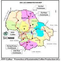
LAK DISTRICT AND THE PROJECT TARGET COMMUNES
General information:
Lak is famous for its lake, the Lak Lake. With a total surface of 700 ha it is the largest natural lake in Vietnam. The district has beautiful landscapes with a long standing tradition for culture and art of the local ethnic minorities. Lak District is located along the National Road No. 27 which joins the National Road No.20 leading to Dalat City, HCM City and other southern provinces. It is 50 km South of Buon Ma Thuot City. The total natural area is 125,604 ha. There are 11 administrative units including 10 communes and 1 township and 120 villages. A relatively good road network connects every commune centre to the main district town, Lien Son. All communes have access to the electricity grid and are connected to the telephone network.
The total population of the district in 2006 was 57,211 people in 11,376 households. The ethnic minority households account for 61% of all households with a total population of 35,670 people. In 2006, 42.33% of all households were categorised as poor, of which poor ethnic minority households account for 68%. The main ethnic group are the M’Nong People.
Bong Krang Commune, Lak District
Bong Krang Commune is located in the North-East of Lak District, with a total area of 31,738 ha of which agricultural land occupies a cropping area of 1,505 ha and of 2,073 ha, which is so far unutilised. Forest land accounts for 27,834 ha, of which 27,634 ha are special use forests. residential land for 44 ha and other land for 327 ha.
The commune includes 10 villages and 1 hamlet with 976 households and 5,348 inhabitants, of which 5,250 are ethnic minorities (992 households). In 2005, 663 poor households were recorded.
The main source of income is agriculture. In 2006, an area of 1,263 ha was under seasonal crops while perennial crops, e.g. coffee or cashew, occupied 222 ha. However, due unfavorable climatic and soil conditions farmers in the commune tend to shift further towards traditional rice and maize production, thus increasing the risk of soil degradation and reducing incomes. The introduction of suitable upland farming based on sound crop rotations with improved maize varieties and beans, fodder cultivation, silage and animal health is therefore a major requirement in the commune. In addition, there is urgent need for alternatives to the previous cash crop strategy, e.g. through introduction of appropriate intercropping in cashew or bamboo for shoot production or through contract farming of cassava, in rotation with beans, and of peanuts in- and off-season. Since the majority of forest land in the commune belongs to a forest conservation area, the communities have only limited access to forest land.
Dak Nue Commune, Lak District
Dak Nue Commune is located in the South West of Lak District with a total area of 12,624 ha. Agricultural land occupies a total area of 1,278 ha. Forest land accounts for 8,768 ha, residential land for 40 ha and other land for 2,538 ha.
The commune includes 11 villages, including 3 Kinh villages and 8 ethnic minority villages (7 in forest areas) with a total population of 4,170 inhabitants 898 households. In 2006, 542 poor households were recorded. The ethnic minorities account for 65% of all households. There are 542 poor households with 2,477 inhabitants, accounting for 61% of total population. The estimated average food production in 2006 was 620 kg per capita.
The main source of income is agriculture. In 2006, an area of 1,008 ha was under seasonal crops while perennial crops, e.g. coffee or cashew, occupied 271.6 ha. Total forest land area of the commune was 8,768 ha in 2006, of which 3,491 ha is production forest and 5,277 ha special use forest. 1,668 ha of forests land are under household, user group or community management.
EA H’LEO DISTRICT AND THE PROJECT TARGET COMMUNES
Ea H’Leo District is located in the Northern part of Dak Lak province, 82 km North of Buon Ma Thuot City. It borders Ea Sup and Cu M’ga Districts to the West, Gia Lai Province to the North and East, and Krong Buk District to the South. With an elevation of between 400 and 700 meters, Ea H’Leo has a tropical monsoon and midland climate with 2 distinguished seasons. The dry season lasts from November to April, and the rainy season from May to October.
The total natural area is 133,512 ha. There are 11 administrative units including 10 communes and 1 township and 165 villages. The road network connecting every commune centre to the main district town, Ea Drang, is only basic. All communes are connected to the electricity grid (80% of all households) and to the telephone network.
The total population of the district in 2006 was 114,909 people in 23,613 households. The ethnic minority households account for 46.4% of all households with a population of 64,3493 people. In 2006, 5,421 (22.5%) of all households were categorised as poor, of which poor ethnic minority households account for 38%. The district is home to 23 ethnic minorities, mainly Ede and J’Rai accounting for 40% of total population.
Ea Sol Commune, Ea H’Leo District
Ea Sol is located in the North East of the district, some is 20 km from the district center. Ea Sol has a total area of 23,150 ha. in which 5,724.08 ha is agriculture land (24.7%); 13,525.6 ha is forest land (58.42%), mainly natural forests and the remaining areas is other lands (16.9 %).
The basaltic soil as well as climate are suitable for perennial crops, such as robusta coffee, rubber, and pepper.
The total number of households in the Ea Sol is 2,067 including 10,501 inhabitants in 2006. In 2005, there were 741 poor households, but by the end of 2006, the number of poor households is reduced to 514. There are 14 villages and 6 hamlets. The local ethnic minorities, i.e. mainly Jrai and Ede account for 67.2% of the commune’s total population. 24.2% are Kinh people while other minorities from the North of Vietnam with Thai as the largest of these groups account for 8.6%.
The main income for farmers is based on agriculture. The main products are rice, beans, maize, cashew, coffee, black pepper, and fruit trees. In recent years, the productivity of crops and livestock could be gradually increased through introduction of improved varieties and better animal husbandry practices. Combined with the results from the implemented national programmes on poverty reduction, village development and extension (NPs 132, 134, 168, 139) this has contributed to reduce poverty in the commune. The average income of local people in 2006 was VND 3.8 million, i.e. 238 USD.
Ea Hiao Commune, Ea H’Leo District
Ea Hiao is located in the North-West of Ea H’Leo District, and is 18 km from the district center. Its total natural area is 13,040 ha with 2,665 ha of agricultural land (20%), 4,864 ha of forest land (37%) and the remaining area being reserved for construction of infrastructure, residential land etc. The topography is secluded with hills and rivers limiting the access to the land resources. Villages are connected only by dirt roads, which make transportation a particular problem during the rains and the rural water supply and sewage is still underdeveloped. Only 9 out of 23 villages access to electricity.
The population is scattered along lower hill sides, rivers and streams. The commune is home of 15 different ethnic minority groups. There are 2,487 households with 12,353 inhabitants, in which the number of EM households is 691 comprising of 2,218 people. Of the total of 741 households, 269 households belong to local ethnic minority groups and 178 households to in-migrated minorities. All ethnic minorities groups account for 34%, while the indigenous groups account for 17%. The commune is divided into 23 villages, of which 5 villages indigenous minority villages. The economy depends mainly on agriculture, i.e. staple food production, coffee, pepper, and rubber. The average annual per capita income is 1,429,200 VND (89 USD).
|


)

